Experience the dramatic landscape reshaped by the 1980 eruption, where lava domes, blast zones, and regrowing forests tell a powerful story of destruction and renewal. Explore scenic viewpoints, lava trails, and visitor centers while witnessing one of the most active and studied volcanoes in the world.
Windy Ridge offers one of the most dramatic and unforgettable viewpoints at Mount St. Helens, placing visitors within the heart of the 1980 eruption blast zone. Sweeping views of Spirit Lake, the volcano’s crater, and the surrounding landscape reveal both the destruction and remarkable recovery that followed the eruption. Scenic trails and interpretive viewpoints provide a close-up look at one of the most fascinating volcanic landscapes in the Pacific Northwest.
Sitting on the northwest side of Mount St. Helens, this area offers breathtaking lakeside views, interpretive trails, and scenic ridge hikes. Visitors can take in sweeping vistas of the volcano, the Spirit Lake basin, and the surrounding landscape as it continues to recover and evolve following the historic 1980 eruption.
Forever changing over 200 square miles of rich forestland into a gray, lifeless landscape, the 1980 eruption of Mt. St. Helens has had an impact so powerful, you have to see it to believe it. Over two decades later, witness the mountain’s slow but steady recovery. Journey through this healing landscape and behold nature’s awesome power.
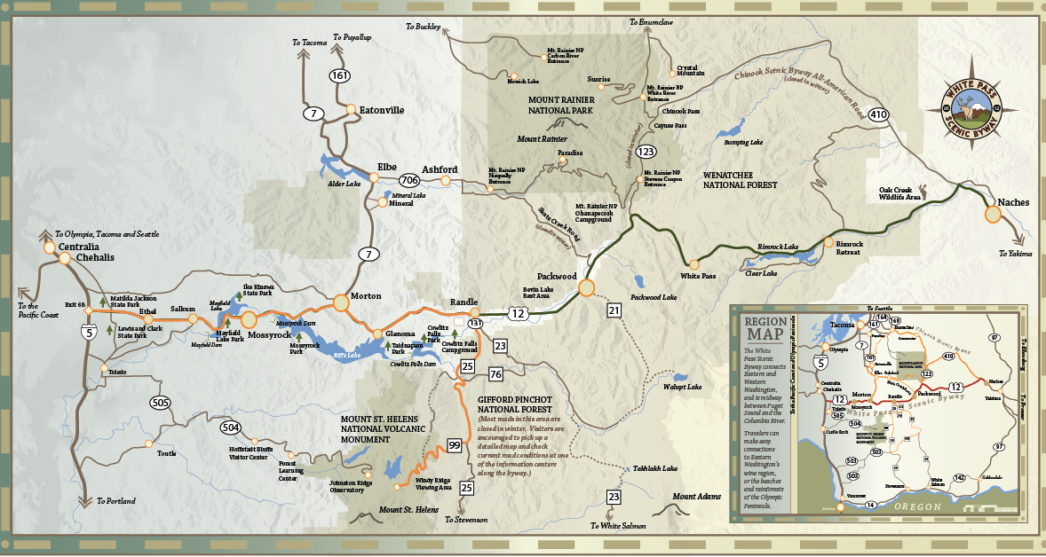
From US-12 (White Pass Scenic Byway) travel east to Randle, Washington.
In Randle, turn south onto State Route 131. After about 2 miles, SR-131 ends at a T-intersection. Turn left onto Forest Road 25 (FR-25). Follow FR-25 south for approximately 25 miles.
Turn right onto Forest Road 99 (FR-99). This is the signed turn for Windy Ridge Viewpoint / Mount St. Helens National Volcanic Monument.
Continue about 9 miles to the Windy Ridge parking area and viewpoint overlooking Spirit Lake and the blast zone.
FR-25 and FR-99 typically open late June or July (not early spring) due to deep snowpack
Roads usually close again in October or after the first major snowfall
These are narrow mountain roads with limited services — fuel up in Randle
Expect steep grades and sharp curves
Cell service is very limited after leaving Randle. Download maps before heading out.
Before 1980, Mount St. Helens was blanketed in dense forests, alpine meadows, rivers, and lakes. Old-growth trees covered much of the mountain, and wildlife, including elk, deer, birds, amphibians, and small mammals, thrived across a wide range of elevations. Before the 1980 eruption, Mount St. Helens was widely regarded as one of the most symmetrical and visually striking volcanic cones in the Cascade Range, often described as a nearly perfect cone.
On May 18, 1980, a massive volcanic eruption at Mount St. Helens dramatically reshaped the surrounding landscape. A powerful landslide and lateral blast flattened vast forests, while ash and debris swept through valleys and river systems. The eruption created entirely new landforms, including lava domes, newly formed lakes, and exposed ridges of volcanic rock. In just minutes, ecosystems that had developed over centuries were completely transformed, marking one of the most significant volcanic events in modern U.S. history.
In the years following the eruption, Mount St. Helens became a living laboratory for ecological recovery. Plants began returning sooner than expected, with wildflowers, grasses, and shrubs taking root in volcanic soils. Over time, forests slowly regenerated, wetlands formed, and streams stabilized, creating new habitats.
As plant life returned, wildlife followed. Today, visitors may spot elk grazing in recovering meadows, amphibians near wetlands, birds nesting along cliffs and forests, and small mammals adapting to the ever-changing terrain. Each season brings visible signs of renewal.
Mount St. Helens continues to evolve, offering a rare opportunity to witness nature’s resilience and the ongoing process of recovery firsthand.
For thousands of years, the Mount St. Helens area has been deeply significant to Indigenous peoples, including the Cowlitz, Yakama, and other tribes, who lived, traveled, and gathered throughout the region. The mountain was an important cultural and spiritual landmark long before modern settlement.
In the late 19th and early 20th centuries, the surrounding forests supported logging, recreation, and growing communities. The May 18, 1980 eruption of Mount St. Helens forever altered both the landscape and the cultural identity of the region, drawing global attention and reshaping how people understand volcanic forces. Today, the area serves as a place of learning, reflection, and connection, honoring both its deep cultural roots and its powerful natural history.
Questions or Comments? Drop us a note we’d love to hear from you.